Real quick:
http://en.wikipedia.org/wiki/Insolation
Insolation is basically the same as measuring the total incoming solar radiation, and measured in the form of watts per squared meter (W/m2).
When considering the triggering source for thermals, or any convectively driven system, we often use heat flux values to represent the available energy. For example, check these out (search for earth energy budget to see other versions):
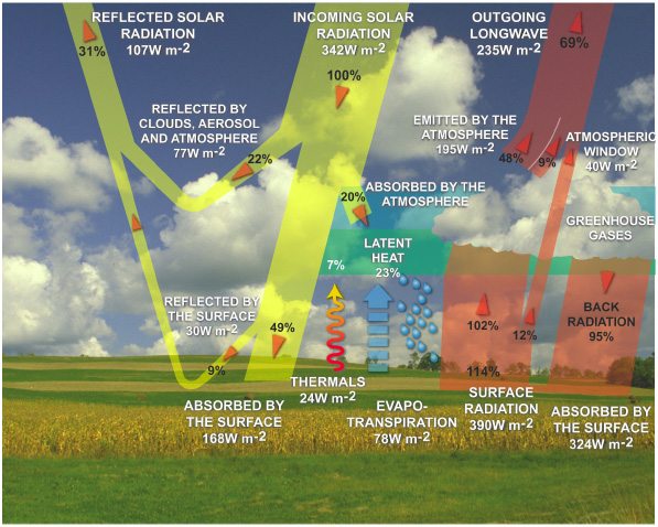

Taken from http://www.sciencepartners.info/?page_id=578 and
And the cycle...


Note the intersection of incoming and outgoing radiation! Perhaps the most important part of all this babble I'm spouting out. Why? Because this happens in the large scale, and even helps explain the lag from winter and summer solstice to max and min temps on the planet--the planet stores a whole lotta energy and that's given up as temperature slowly.
Back to the Energy Budget... At any given time the budget should balance to zero (0). It's extremely hard to measure this system and actually come up with a zero, but in theory that's how it should work.
What we as pilots *might* care about at the end of the day, is how much available energy is available at the surface to help drive thermals. This is very different than just measuring the incoming solar radiation (or taking an hourly insolation measurement). For example, on a clear sky day that is moderately unstable, the same amount of incoming solar radiation is available over a large body of water (the Great Salt Lake for example) as over the land (the slopes of the Wasatch). Of course, the angle of the terrain in relation to the sun (aspect and slope) dictate how much energy can be "used" at any given spot.
Meteorologists use the term Sensible Heat Flux to describe the amount of energy in W/m2 at the surface or "skin" of the earth that is exchanged with the atmosphere. It's the conductive heat flux, and it can be positive or negative. Sensible heat flux is used in well known equations to predict the depth of the boundary layer which pilots can use for flight--or specifically, the estimate of where the vertical velocity reaches zero, or better yet, matches the sink rate of the glider you're flying. This is basically used to find the top of usable lift, which is a parameter in XC Skies, Dr. Jack's BlipMaps, and RASP.
More or less... I know I've overly simplified the above statements. Search the term "sensible heat flux" on the Inter Web and read more if you're interested. :)
If enough heat is stored in an object from incoming solar radiation throughout the day, depending on the conductive properties of that substance, it may continue to exchange heat with the atmosphere, even after dark. So a large desert (I'm thinking of Southern Wyoming) near and just after sunset can continue to produce usable lift due to radiative forces given the right instability of the overall air mass.
And so this is why I think in terms of wanting to be over this region in WY at sunset in strong winds. It gives the best possible scenario for XC distance much later into the day. This is to say, starting in the mountains early in the day and ending a flight over flatland with stored surface heat and moderate winds is ideal for big XC flights. Think: Jupiter to Moab, or Jupiter to Rawlins.
-CG
No comments:
Post a Comment