Saturday, August 31, 2013

OD Nats 2013 Aug 31 Weather

Yesterday was no surprise to us when deep convection fired off in and around the area, starting early and not settling down for most of the night in some locations east. Given this trend coupled with the comments mentioned in the discussion below, we can expect a very active TS day, especially from Provo south. The north is a bit drier.

Area forecast discussion 
National Weather Service Salt Lake City Utah 
509 am MDT Sat Aug 31 2013 


Synopsis...a very moist airmass will remain in place across 
southern Utah today...while drier air remains across the far 
north. A weak weather system will bring this moisture northward 
Sunday into Labor Day. High pressure will redevelop over the 
region for the midweek period. 


&& 


Discussion...a broad middle level ridge encompasses much of the 
interior west this morning...with an embedded east-west oriented 
trough situated just south of the Utah/Arizona border. A very moist 
airmass is in place across southern Utah...with GOES derived precipitable water 
values at or above 1.25 inches...and values over 2 inches sitting 
just south of utahs Dixie along the Arizona/Nevada border. This moisture 
rich airmass combined with afternoon heating and the proximity to 
the aforementioned trough should allow for fairly widespread 
convection this afternoon and evening over southern Utah. A light 
easterly component to the flow aloft coupled with a tendency for 
storms to propagate into deeper moisture/instability should push 
this activity slowly downbasin across southern Utah...enhancing the 
flash flood threat. As such have issued a Flash Flood Watch for 
southwest and south central Utah for this afternoon and evening. 


Further north a ridge axis downstream from the aforementioned 
trough sits across northern Utah. A fairly sharp moisture gradient 
extends across northern Utah with the airmass remaining quite moist 
across areas south of I-80. Will likely see scattered convection 
this afternoon from roughly the southern oquirrhs southward into 
central Utah. Locally heavy rain will also be possible with this 
activity...although coverage will likely be more limited than 
areas further south. As such have left this area out of the watch 
for now. 


The middle level trough over northern Arizona is forecast to slowly lift 
northward across the forecast area beginning Sunday across 
southern Utah...and continuing into Monday over the north. As such 
anticipate another very active convective day over southern Utah 
Sunday afternoon...with the north becoming more active during the 
evening hours..and likely continuing overnight as this wave 
approaches. Have increased probability of precipitation over northern Utah 10-20 percent 
Sunday afternoon through Sunday night and into Monday morning. 


Thunderstorm coverage on Labor Day will be dependent on how 
quickly this wave moves northward...and the models at this point 
do not seem to have a firm grasp on this. Have maintained a chance 
of showers/thunderstorms into Monday afternoon over most areas 
with the highest probability of precipitation in the north. However...if this wave lifts 
into Idaho by early afternoon subsidence would likely inhibit 
additional convective development areawide. 


In the wake of this feature...the middle level ridge is forecast to 
strengthen across the region Tuesday into Wednesday. Sufficient 
moisture will remain to support a threat for showers and 
thunderstorms...however warming aloft will likely limit 
instability...with convective activity remaining largely confined 
to the higher terrain. An upper low which is forecast to reside 
off the Pacific coast during the first half of the week is 
forecast to move inland and through the northern rockies late in 
the upcoming week. This looks to suppress the ridge axis southward 
and allow for a drier westerly flow over northern Utah. 

Looks like a tough next 2 days ahead in terms of weather. So much moisture for being so late in the season around here!

See water vapor image here:


Winds aloft make the position of moisture a difficult prospect. Expect to see N to NW winds, albeit light, prevail across the region and strengthen as the day evolves. This makes heading north into the drier air mass very challenging, if not impossible. A quick look out the window this morning showed fairly large convection lit by the sunrise over the western deserts already. So expect to see another repeat of nuclear OD to the west. With a northerly flow, however, perhaps it will stay to the west? Hard to say.

Cloud base expected to be around 14-15k over the eastern and high wasatch terrain again. Yesterday did well with this prediction, so I suspect it will do well today.

More later.

-CG

Friday, August 30, 2013

OD Nats 2013 Aug 30 Weather

Friday forecast discussions are packed full of goodness, like a well balanced cereal.

Area forecast discussion 
National Weather Service Salt Lake City Utah 
311 am MDT Friday Aug 30 2013 


Synopsis...northern Utah will see a drying trend Friday through 
Sunday...with moisture returning to the area on Labor Day. Deep 
moisture will remain in place across the south through the Holiday 
weekend. 


&& 


Discussion...water vapor loop shows a ridge centered over The 
Rockies and a series of closed lows approaching the Pacific 
northwest. Several disturbances are marching westward across New 
Mexico and Arizona. Acars 400-250mb wind observations place a 
75-95kt cyclonically curved jet over the Pacific northwest. 
Rap...GOES...GPS sensors...and 00z slc radiosonde observation indicate precipitable 
water values range from 0.40"-0.70" eastern mountains to 1.10"-1.50" 
western valleys. 


Valley surface dewpoints are generally 45f-55f...closer to 60f along 
the Arizona border. Column moisture quite rich across the western 
valleys...maximized over utahs Dixie. With the ridge in 
place...believe Arizona disturbances will be kept south of the Utah 
border today and much of the convection will be significantly tied 
to the higher terrain. This is supported by the hrrr-3km simulated 
reflectivity. Storm motions are none which means if this is the case 
it will be difficult to get good coverage over adjacent valleys. But 
it also means if a storm were to develop over the adjacent 
valleys...it will sit and produce locally heavy rainfall with a 
flash flood threat. Have added mention locally heavy rainfall to 
southern zones but no watch at this time as coverage may be limited. 


With drier conditions and the ridge in place...kept probability of precipitation out of the 
forecast for the north today. It will remain quite hot given lack of 
convection and 700mb temperatures rising toward +16c. The record for 
number of 95f days in a Summer at Salt Lake City will be broken 
today. Speaking of records...the high min record for today at Salt 
Lake City is 71 set in 2012. This record is also in jeopardy 
depending on our morning lows. 


Global models indicate a series of disturbances with origins over 
the Gulf of Mexico will round the broad central Continental U.S. Ridge and 
impact the Great Basin this weekend. The combination of moisture 
transport and these disturbances should yield better coverage for 
convection especially the south. However...both GFS and European 
indicate in 850-500mb streamlines/specific humidity fields that a 
drier northerly flow may be present across the northern zones 
Saturday and somewhat Sunday. Slow storm propagation would favor 
flash flood threat Friday through Sunday across southern Utah if 
cloud cover remains across Arizona as currently depicted in guidance. 


Moisture surge is reinforced early next week with southerly return 
flow establishing with the ridge easing back to our east. GFS has 
been trying to bust a trough/closed low into the region for many 
runs and continues to back off as time approaches. Favor the 
European with a moist flattening ridge remaining the dominating 
feature over the region through the work week. Perhaps a more 
fall-like northwesterly flow establishing during the second week of 
September. 


&& 

You don't need to read all of it or even understand it all, but note the mention of drying trend today through tomorrow. This concerns me because I don't see that in the models.So is the forecaster speaking in general or relative terms? Hard to say... If you look at the precip potential from the NAM, you'll see what I mean. Looking at CAPE and LI values also indicate a lot instability with plenty of moisture on tap. It's hard to imaging today being less dry than yesterday, in fact I think it's the other way around... BUT I have been wrong on the timing of OD in the last 2 days, so perhaps I'm not quite calibrated.

Winds... Today we're looking at a near identical direction and speed as yesterday. It might even feel light and variable, but it is SSW and will be stronger around Ogden and more westerly out east of Evanston.

Top of lift looks a little higher than yesterday, at around 11-ish on the lower slopes of the wasatch and close to 15k deeper east, which is what cloudbase will be.

More later. Looks like another similar day.


Wednesday, August 28, 2013

OD Nats 2013 Aug 29 Weather

Looking like another reasonable day to try for XC. Expect later afternoon and early evening TS to form like today (very impressive over Nebo at sunset!). Here's the NWS discussion.

Area forecast discussion 
National Weather Service Salt Lake City Utah 
847 PM MDT Wednesday Aug 28 2013 


Synopsis...somewhat drier air will move into the intermountain 
west tonight and Thursday as high pressure builds over the 
region. Deeper moisture is expected to move into southern Utah 
beginning Friday...then into northern Utah for the beginning of 
next week. 

&& 

Discussion...a fairly moist boundary layer remains in place 
across the forecast area this evening as evidenced by the 00z 
kslc sounding...surface dew points in the 50s across most valley 
locations...and GOES derived precipitable water values at or above 0.75 inches. 
However...much drier air aloft which is also evident in the 00z 
sounding has advected across the forecast area from the 
southwest...and this drier air greatly limited the coverage and 
intensity of convection this afternoon. Isolated showers and 
thunderstorms continue this evening...but should diminish over the 
next couple of hours with the loss of daytime heating. 


A middle level ridge extending into the central rockies is forecast 
to strengthen a bit on Thursday...which will likely continue to 
inhibit much more than diurnally driven terrain based convection. 
This ridge axis looks to extend along the Utah/Arizona border Friday 
through the weekend. Deeper moisture may work its way back into 
the southwest during this time...however convection across the 
remainder of the area will likely remain limited. This moisture is 
expected to spread back north by early next week. 

Updated earlier to trim probability of precipitation over the south...and will plan to 
update again and remove evening wording once convection 
diminishes. 

&& 

Expect winds to be single digits up to 10,000 ft from the SW, with winds at 14k around 12-14 mph. This makes for a good XC conditions for routes into SW Wyoming. Hopefully we won't see over development in the higher terrain until late in the day.

More at the official wx brief.

-CG


OD Nats 2013 Aug 28 Weather

Looks like the overall air mass around the region is a bit drier, with precipitable water values at only .75 inches :) That's a relative joke. Here's the discussion

Area forecast discussion 
National Weather Service Salt Lake City Utah 
245 am MDT Wednesday Aug 28 2013 


Synopsis...temperatures will warm with a ridge of high pressure 
building into the region. However plenty of moisture will keep the 
threat of daily isolated to scattered showers and thunderstorms. 


&& 


Discussion...water vapor loop shows a ridge over the central Continental U.S. 
And a trough off the Pacific coast. Several disturbances are 
rounding the ridge from the Gulf of Mexico and northern Mexico 
toward The Four Corners. Acars 400-250mb wind observations place a 
75-105kt southwesterly jet from central California into the northern 
rockies. Rap...GOES...GPS sensors...and 00z slc radiosonde observation indicate 
precipitable water values range from 0.70"-1.55". 


As the central Continental U.S. Ridge tries to build westward...subtle drying 
and warming will gradually take place from east to west. While the 
column dries a bit especially east...surface dewpoints are still 
well into the 50s most valleys. Enough moisture will remain in place 
to support more traditional diurnal convection during the next 
several days initiating on the higher terrain. Locally heavy 
rainfall is still a threat. 


Global models indicate a series of disturbances with origins over 
the Gulf of Mexico will round the broad central Continental U.S. Ridge and 
impact the Great Basin next weekend. The combination of moisture 
transport and these disturbances should yield better coverage for 
convection. However...both GFS and European indicate in 850-500mb 
streamlines/specific humidity fields that a drier northerly flow may 
be present near the Idaho border. So ended up increasing probability of precipitation 10% 
across southern Utah and lowering 10% near Idaho this weekend. 


GFS now on board with European maintaining another surge in moisture 
by the middle of next week as the ridge once again propagates to our 
east opening up a more southerly flow. No changes in scattered pop 
distribution yet. 

I suspect we're looking better for a chance of XC flying over the next few days, with today being more of a transition day in terms of percip and TS potential.

Expect the unexpected. We have plenty of potential for TS and the clear skies will help keep the day active with deep cumulus clouds. Some will be threatening, some will only look scary--I for one will err on the conservative side rather than roll the dice to find out, so be careful and watchful.

Winds are SSW, with light southerly flow in the valleys and maybe 12 mph around 14,000 ft, which will likely be about cloud base for the day. Temps will rebound, but bring warmer clothes for flying, as 14k is around 40 F today.

UPDATE: Models seems to disagree with winds aloft today, as do the official aloft forecast for SLC from the NWS. We could see as much as 16mph near 14,000 feet today. Real-time surface obs this morning near ridge top are showing as high as 15mph at 10,000 ft. This is compressed flow, so assume aloft is more like 10mph at 10k feet.

A MUCH drier air mass is overhead by mid day, according to the GFS, so this should help keep TS scattered over favorable locations in high terrain just as the NWS notes indicate.

Not sure what else to post. We'll brief in person on launch.

-CG

Tuesday, August 27, 2013

Upload your track logs!

Here's that Uinta Flight Bill Belcourt and I did last month. The GFS forecast did OK. Not perfect by any means. The NAM is what I was looking at in the morning, which likely validated better than the GFS. Eventually I'll get around to creating that feature for validation.


http://www.xcskies.com/cgi-bin/map/reviewlog.cgi?tid=1843

You can upload your tracks here:
 http://www.xcskies.com/cgi-bin/map/uploadlog.cgi

Gavin McClung's flight is here:
http://www.xcskies.com/cgi-bin/map/reviewlog.cgi?tid=1830


-Chris Galli

OD Nats 2013 Aug 27 WX Review

Today was cancelled, so I decided to work. As I left around 5:30 pm I walked out into a sunny, nice looking sky in northern SLC. Had we completely missed and squandered the day?! Ugh! I took a peek at the radar and satellite imagery, and felt better that the day truly was cancelled. Here's what was lurking on the horizon, and by sunset it was just getting strong!


Well, golly gee! Seems like we did OK.


Satellite imagery at 3pm ish looked like this:


That blue-green spot in the center is the north tip of the Great Salt Lake. Impressive.


For tomorrow I'm extremely optimistic. Patience will be the name of the game, so get thinking along those lines. We're here to fly a comp, so if waiting several hours on launch for the perfect moment is what it takes, then that's what we'll do. Bring the rain gear and get ready for the next two days. I suspect we'll have windows reasonable enough to get something in.

Also study the maps and start thinking about what moves you want to make heading north. Note the airspace and understand where you can and can't be past SLC.

Weather update to follow early in the morning.

-CG


OD Nats 2013 Aug 27, Weather Part II

Anyone remember the movie Groundhog Day? Today looks like a similar day compared to yesterday, except with more chance of convective precip in mix. Here's the discussion:


Area forecast discussion 
National Weather Service Salt Lake City Utah 
245 am MDT Tuesday Aug 27 2013 


Synopsis...the deep layer moisture plume with a tropical tap 
will remain in place through tonight. A more typical monsoonal 
pattern will then prevail tomorrow into the weekend. 


&& 


Discussion...water vapor loop shows the remnants of Ivo spilling 
northward into the region between a ridge over the central Continental U.S. And 
a trough off the Pacific coast. Acars 400-250mb wind observations 
place a 90-130kt southwesterly jet from central California into the 
northern rockies. Rap...GOES...GPS sensors...and 00z slc radiosonde observation 
indicate precipitable water values range from 0.80"-1.10" across the 
north to 1.40"-1.60" across the south and east. 


With the Flood Watch expiring a few hours ago at midnight and 
convection approaching from Arizona...already issued Flash Flood 
Watch for much of central and southern Utah through 11pm this 
evening. 


Dewpoints have rised to near 70f across far southern Utah and are in 
the middle 50s to middle 60s across most valleys. As the central Continental U.S. 
Ridge tries to build westward beginning today...moisture and 
weakening disturbances from Ivo will track further to the west. 
Drying and warming will gradually take place from east to 
west...though enough moisture will remain in place to support more 
traditional diurnal convection. 


Global models indicate a series of disturbances with origins over 
the Gulf of Mexico will round the broad central Continental U.S. Ridge and 
impact the Great Basin next weekend. Temperatures should cool as the 
western extent of the ridge is eroded by these disturbances and more 
expansive convection takes place. Not buying off on the drying 
offered by the GFS solution beyond next weekend. 
 
I think that sums it up. NWS bumped chance of TS from 30% to 40% for the SLC area and kept 30% for the Provo area. Up north we are looking at 30% chance around Ogden. What does all of this mean? Well, here's the relative humidity profile:


Again we're looking at a very deep layer of moisture that convective clouds can tap into. It's hard to imagine the day being usable for XC-- a day with half the TS possibility is hard to imagine!


Cloud base will likely be low again today, giving TS even more of a chance to blow up. Looking over the skewt plot validates what the forecast is anticipating, with a very deep layer of moisture aloft. On the bright side, winds below cloudbase will remain fairly light, at around 10 mph or less from the S...so I guess we got that going for us, which is nice.


And what about radar and water vapor imagery? Well,vapor loop shows an interesting space of drier air moving overhead at the moment, however, this is likely to give way to increased moisture within 2 hours from now (7am), and this period of less cloud will actually give more energy into the system with clearer skies for a bit, which will drive convective storms even stronger. Radar is quiet at the moment.


Water Vapor Satellite Image

Bottom line: it's hard to imagine flying paragliders in this area today. I don't see a place drivable by 4 hours which could support an XC attempt with any certainty.

-CG


Monday, August 26, 2013

OD Nats 2013 Aug 27 Weather Synopsis

Tuesday is again an interesting day. First, I love this XC Skies time-height series plot. It's relative humidity to 40,000 ft with winds depicted as well as the evolution of the boundary layer. This one plot can tell me if I should call in sick for the next day or not. It literally has that much information implied within it.


It's hard to not notice the amount of moisture shown as a percentage of relative humidity aloft over night and into tomorrow. Winds seem reasonable in the lower levels from the south. But the moisture convective clouds can tap into is impressive, and so I suspect we're in for a ride.

More updates in the morning after new model runs are out and the NWS weighs in with their thoughts...

-CG

Insolation

Yesterday's discussion on launch regarding insolation got me thinking a little more. I rarely think in that term, which is why it "sounded about right" to me. So a quick review of this term reminds me of why I've never used it as an example of available surface energy when it comes to soaring.

Real quick:

http://en.wikipedia.org/wiki/Insolation

Insolation is basically the same as measuring the total incoming solar radiation, and measured in the form of watts per squared meter (W/m2).

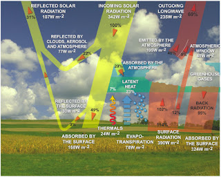
When considering the triggering source for thermals, or any convectively driven system, we often use heat flux values to represent the available energy. For example, check these out (search for earth energy budget to see other versions):


Taken from http://www.sciencepartners.info/?page_id=578 and

And the cycle...

http://www.fas.org/irp/imint/docs/rst/Sect14/t_diurnal3_free.jpg


Note the intersection of incoming and outgoing radiation! Perhaps the most important part of all this babble I'm spouting out. Why? Because this happens in the large scale, and even helps explain the lag from winter and summer solstice to max and min temps on the planet--the planet stores a whole lotta energy and that's given up as temperature slowly.


Back to the Energy Budget... At any given time the budget should balance to zero (0). It's extremely hard to measure this system and actually come up with a zero, but in theory that's how it should work.

What we as pilots *might* care about at the end of the day, is how much available energy is available at the surface to help drive thermals. This is very different than just measuring the incoming solar radiation (or taking an hourly insolation measurement). For example, on a clear sky day that is moderately unstable, the same amount of incoming solar radiation is available over a large body of water (the Great Salt Lake for example) as over the land (the slopes of the Wasatch). Of course, the angle of the terrain in relation to the sun (aspect and slope) dictate how much energy can be "used" at any given spot.

Meteorologists use the term Sensible Heat Flux to describe the amount of energy in W/m2 at the surface or "skin" of the earth that is exchanged with the atmosphere. It's the conductive heat flux, and it can be positive or negative. Sensible heat flux is used in well known equations to predict the depth of the boundary layer which pilots can use for flight--or specifically, the estimate of where the vertical velocity reaches zero, or better yet, matches the sink rate of the glider you're flying. This is basically used to find the top of usable lift, which is a parameter in XC Skies, Dr. Jack's BlipMaps, and RASP.

More or less... I know I've overly simplified the above statements. Search the term "sensible heat flux" on the Inter Web and read more if you're interested. :)

If enough heat is stored in an object from incoming solar radiation throughout the day, depending on the conductive properties of that substance, it may continue to exchange heat with the atmosphere, even after dark. So a large desert (I'm thinking of Southern Wyoming) near and just after sunset can continue to produce usable lift due to radiative forces given the right instability of the overall air mass.

And so this is why I think in terms of wanting to be over this region in WY at sunset in strong winds. It gives the best possible scenario for XC distance much later into the day. This is to say, starting in the mountains early in the day and ending a flight over flatland with stored surface heat and moderate winds is ideal for big XC flights. Think: Jupiter to Moab, or Jupiter to Rawlins.

-CG

Sunday, August 25, 2013

OD Nats 2013 Day 2 Weather

Radar showing precip to the south of Provo already near Nephi moving into the area, with larger rain event further south in southern Utah. This is moving north, although slowly. Radar also shows precip to the NE past Ogden, which means using a northern launch for the day is not a good option given it's already under inclement weather. So what do the NWS folks have to say?

Forecast discussion is helpful with mention of all the ingredients that we wish were not present.

Area forecast discussion 
National Weather Service Salt Lake City Utah 
245 am MDT Monday Aug 26 2013 


Synopsis...the deep layer moisture plume across Utah will remain 
in place into the middle of the week. Widespread precipitation is 
expected with heavy rain possible across mainly the southern half 
of the state through tonight. 


&& 


Discussion...water vapor loop shows the remnants of Ivo spilling 
northward into the region between a ridge over the central Continental U.S. And 
a trough off the Pacific coast. Acars 400-250mb wind observations 
place a 75-115kt southwesterly jet from Southern California into the 
western Great Basin and northern rockies. Rap...GOES...GPS 
sensors...and 00z slc radiosonde observation indicate precipitable water values range 
from 0.75" across the north to 1.50" across the south and east. 


Flood Watch remains in effect today and may need to be extended in 
length by the next shift. The combination of moisture from Ivo and 
dynanmical lift due to the right entrance region of the jet will 
continue to support locally heavy rainfall in the watch area. 


Raised probability of precipitation mainly across the south and east through tonight. The 
jet will serve as a strong delineation between locations favored for 
rainfall (south and east) vs. Locations hoping to see isolated 
convection (northwest). This setup will continue to support cloudy 
and cool conditions. 


As the central Continental U.S. Ridge tries to build westward beginning 
Tuesday...moisture and weakening disturbances from Ivo will track 
further to the west. Drying and warming will take place...though 
enough moisture will remain in place to support more traditional 
diurnal convection more likely to initiate on the higher terrain. 


Global models indicate a series of disturbances with origins over 
the Gulf of Mexico will round the broad central Continental U.S. Ridge and 
impact the Great Basin next weekend. Temperatures should cool as the 
western extent of the ridge is eroded by these disturbances and more 
expansive convection takes place. Not buying off on the drying 
offered by the GFS solution beyond next weekend. 

Winds aloft are still reasonably light from the southwest, with winds at 12,000 ft forecast to be SSW at 11 knots, lightening to 9 knots by mid day. Winds at 18K are a bit stronger at about 20 kts.

Considerable cloud cover is already in place this morning and this will continue to increase throughout the day. There is clearly drier air to the NW of our region, but this is not expected to move into the SLC valley.

Not much rain is expected to hit SLC proper over the next 12 hours, with the NDFD grids indicating .01 inches trace amounts, but extensive cloud cover is enough to dampen any useful convective potential for soaring. There is a chance of scattered TS but these are likely going to be driven by other forces than surface heating. Where lift would be usable, I suspect one would not want to be in that location in the paraglider!

Today is a great day to do lots of things in Utah, but flying XC is likely not one of them. There doesn't seem to be much reason to explore the day's forecast in any more detail, unfortunately.

Update: quick shot of visible 1km satellite image over the region. Note the NW is slowly getting more moisture as this beasty pumps from the south.


-CG


Useful Regional Weather Links

Here are some useful links that I look at from time to time. Depending on what one resource shows, I'll review the day in different terms.

Overall water vapor and satellite images of the US:
http://www.weather.gov/satellite?image=wv#wv

Western Region Headquarters Satellite Loop Products:
http://www.wrh.noaa.gov/satellite/

Winds aloft for the region (I rarely look at this because this is always best represented in the models):
http://aviationweather.gov/products/nws/saltlakecity

Lots of goodies on this page:
http://forecast.weather.gov/MapClick.php?map.x=197&map.y=163&minlon=-115.5&maxlon=-108.5&minlat=36.96&maxlat=42.68&mapwidth=354&site=slc&zmx=1&zmy=1#.UhrOA22BW_4


XC Skies, of course:
http://www.xcskies.com/

Locally run RASP for Utah by Jonathan Foster (So cool and thanks!!)
http://uhgpga.org/RASP/univiewer.html


I'll add more as I think about them...and feel free to post yours in the comments if that works.

-Chris Galli


OD Nats 2013 Day 1

August 25, 2013. Written after the fact for posterity.

Today is a tricky day to forecast for the Northern Wasatch. With the NWS discussion boldly stating how exceptional the precipitation events could be for the day in southern and eastern Utah, it was hard to corroborate the comments when looking at the water vapor images for the morning. The moisture from tropical storm Ivo was clearly visible and pushing north, but a drier than expected air mass was positioned to the west. So... What to do?

We spent the first 2 hours going over the comp details at HQ, which gave ample time to review how large the cumulus were getting. By noon our meeting was over and a thick cirrus layer was overhead, with a clear line stretching across the sky like a wet blanket--it was suppressing the convection and no thunderstorms (TS) developed in the region.

We headed to launch. Waffled a bit, listened to Dave Dixon present a nice speech on key elements to overcoming the mental game of XC flying... By 2:30 Ken decided to cancel the day. Most pilots opted to fly down to get a sense of the area in smooth, buoyant air. Some thermaled in weak lift for well over an hour. I was clearly not a day for any XC flying and given the wild card of potential embedded cumulus overhead, and more moisture on the way, it was the right call.

MODIS image taken at around Noon.


MODIS image taken around 3pm


So what about the forecast? I'll post the full discussion notes, because it sets the stage for the week quite well. From 5:50 AM.

Area forecast discussion 
National Weather Service Salt Lake City Utah 
550 am MDT sun Aug 25 2013 


Synopsis...an exceptionally moist southerly flow will remain over 
Utah through the early part of the week. Widespread precipitation is 
expected with heavy rain possible across mainly the southern half of 
the state through Monday afternoon. 


&& 


Discussion...a southerly flow pattern remains in place over Utah 
this morning. The main features of note upstream of the area include 
an upper trough deepening over the California coast and Tropical 
Depression Ivo off the Baja California coast. Although the airmass has dried a 
little across the west...increasing south flow will draw deep 
tropical moisture from Ivo up into the area today through tomorrow. 


Significant cloud cover from this moisture tap is already in place 
across Arizona and is spreading into Utah. Precipitation is 
currently increasing across southeast Utah and will continue to 
develop across much of southern Utah this morning into this 
afternoon. The bulk of the precipitation can be expected across 
southern...central and eastern Utah. Expect widespread locally heavy 
rain with embedded thunderstorms in these areas through Monday. The 
large amounts of rainfall expected will likely result in enhanced 
runoff in many areas and lead to rises in rivers and streams as well 
as dry washes and slot canyons. A Flood Watch remains in effect for 
this afternoon through Monday. 


Although the deep moisture will not quite make it into the 
northwestern third of the forecast area...expect that isolated to 
scattered convection will still develop today. Precipitable water 
values remain around 0.8 inches there...and given the clear skies 
this morning...there will be plenty of surface heating to help 
destabilize the airmass by this afternoon. Additionally...while 
coverage may be somewhat sparse...these storms could have some 
organization to them given a strengthening jet across far northwest 
Utah associated with the aforementioned trough lifting across the 
northwestern states. Gusty winds will be the primary threat with a 
small potential for hail as well. 


As what remains of the core of the tropical depression weakens and 
lifts across the area Monday night...the heavy rain potential will 
decrease behind it. The airmass will dry out a bit...but since it is 
already starting out extremely moist and because a southerly flow 
will remain in place...plenty of moisture will linger across the 
area to keep showers and thunderstorms active through late week. 
However...with the absence of any significant large-scale 
lift...will see a transition back to more typical monsoonal 
convection rather than widespread heavy rain. 


The onset of meteorological autumn will bring an easing of the 
monsoonal pattern as the jet stream strays farther south and brings 
middle-latitude troughs closer to Utah. Global models indicate one such 
trough will graze northern Utah over the weekend...potentially 
sending a weak cold front into the area and drying the airmass for 
what looks to be an extended period of time. 

 OK. So interesting.And what about the forecast models, like XC Skies? Sky cloud cover did well for noon.


And looking at the evolution of moisture in terms of RH over Provo from 6am to 6pm looked like this:
Note the deepening of the layer aloft as the day progressed. High cirrus was around 35,000 to 40,000 feet over Provo as the tropical storm Ivo approached AZ around noon.

And so what of the diminished lift on the shaded side of this feature? The NAM model shows it well. With reduced surface heating from cloud cover, but increased moisture destabilizing the region, these scenes show what's going on clearly:


with reduced surface heat flux due to cloud cover, the upward momentum is diminished. This means the top of usable lift is much lower than the full depth of the boundary layer. The reduced vertical velocities reflect this as well. All of these are coupled tightly and tell the same story.


Practice Day

Practice day was August 24th, but called off due to severe weather. Registration went well at the North Side point of the mountain.

-Chris Galli